Sturgeon River Watershed 

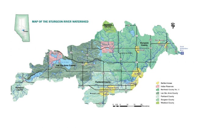
The Sturgeon River is a tributary of the North Saskatchewan River. The Sturgeon River watershed encompasses 331,764 hectares and includes the municipal boundaries of Barrhead, Lac Ste. Anne, Parkland and Sturgeon Counties, the communities of Spruce Grove, Stony Plain, Onoway, Morinville, Bon Accord, Gibbons, Calahoo, Villeneuve, Spring Lake, the First Nations Reserves of Alexis 133 and Alexander 134 and parts of the City of Edmonton and St. Albert (NSWA 2005).

The headwaters of the Sturgeon River begin at Hoople Lake, flow east through Lake Isle, Lac St. Anne, Big Lake, and then empty into the North Saskatchewan River at Fort Saskatchewan.

Sturgeon River Watershed Map

 What is a watershed?

A watershed is an area of land in which all the water drains into the local water body.

 What is a tributary?

A stream or river that flows into the main stem or river.

 NAIT's Sturgeon River Research Project Survey

The City of St. Albert and NAIT are collaborating on Sturgeon River Watershed Research Projects to provide baseline information on the ecological health of the Sturgeon River such as water quality monitoring, impacts of river crossings and biodiversity/riparian habitat assessments.  

Purpose of the Survey

The purpose of this survey is to identify changes in the watershed over the past 50+ years, and to prioritize the issues that you see as most important. This information will also help to direct future NAIT research activities in the watershed. 

Your Role in this Survey

If you are over the age of 18 and live in the Sturgeon River Watershed, we invite you to participate in the online survey, which will take about 15 minutes to complete. Results from the survey will be summarized in reports and shared at community presentations.

Sturgeon River Research Project Online Survey, click here.

For more information about the survey or project, please contact the researchers:

Laurie Hunt, Senior Faculty Researcher, NAIT, 780-378-2856, laurieh@nait.ca

Debbie Webb, Senior Faculty Researcher, NAIT, 780-378-2859, debbiew@nait.ca

 State of the Sturgeon River Watershed Report

The City recently initiated a State of the Sturgeon River Watershed Report which will compile and assess all the information and data available and provide an overview of the condition or health of the watershed. The report will provide a benchmark against which the future activities and changes in land and water management practices aimed at protecting and maintaining the health of the Sturgeon River can be assessed.


A State of the Sturgeon River Report will help to answer the questions:

  • What is the current condition of the Sturgeon River watershed?
  • How does this compare to conditions in the past?
  • What are the cumulative impacts of land and water use on the health of the watershed?
  • What are the critical or emerging environmental, economic or social issues?
  • What are the data/knowledge gaps that need to be filled in?
  • What indicators should be used to monitor and assess the health of the watershed?
  • What mechanisms are in place or need to be in place to maintain and protect the health of the Sturgeon River watershed?


What You Can Do to Help the Sturgeon River Watershed?


  • Get your hands dirty at the City's Clean Up the Sturgeon and tree planting event.
  • Practice the Good Growing Neighbours lawn care tips for a pesticide free yard.
  • Contact the Office of Environment to bring the Yellow Fish Road Program to your neighbourhood.
  • Email environment@st-albert.net for more information on the State of the Sturgeon River Watershed report.